
The Fforestfach History Website
Collieries - Gwalia
Gwalia Colliery
Location: Latitude: 51.652570, Longitude: -4.005289 or Map Grid Reference: SS6137196769
Thomas Richard & Company
Gwalia Colliery worked the 4 foot Seam.
West of Llewitha and South east of Garngoch No.1 Colliery, Garngoch.
His father: Thomas Richard, Thomas Richard Jnr. and his son T. Bryn Richard
were all successful, engineers & surveyors.
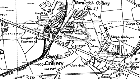
Thomas Richard & Company, Gwalia Colliery map 1903 |
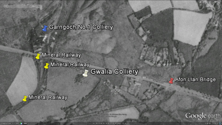
Gwalia Colliery, Google Earth 1945, right of Garngoch Mineral Railway. |
|
|
 | |
 |
 |
|
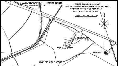
Gwalia Colliery reproduced from (1936-1947) Ordnance Survey map. Without my text and pin reference.
|
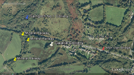
Gwalia Colliery, Google Earth 2009, right of Garngoch Mineral Railway.
|
|
Meaning of "Gwalia"my interpretation, meaning "a poetic name for Wales", source: wikipedia.org/wiki/Gwalia.
Source |
Index |
Area |
Date |
Details |
|---|---|---|---|---|
(OS) |
MAP.1:10:560 GLAMORGANSHIRE |
1900-01 |
No reference to colliery |
|
(RL) |
THE COLLIERS OF THE SWANSEA. |
1903 | Colliery employed 17 men. |
|
(NLT) |
P209 |
STORY OF SWANSEA D & V. |
1903 Mar. 31 |
Sinking commenced, having to work through a bed of sand. |
(NLT) |
P209 |
STORY OF SWANSEA D & V. |
1903 May. 11 |
Came in to contact with the 4 foot coal seam. |
(NLT) |
P210 |
STORY OF SWANSEA D & V. |
1904 |
Mr. T. Richard, Jnr., died (1853-1904). Afterwards the colliery was sold to Mr. David Rees of the Cape Colliery, further west where Days Garngoch is today 2012. |
(OS) |
MAP 1:2:500 GLAMORGANSHIRE |
1916 |
Shows colliery with a shaft, buildings and access to the site from Swansea Road. |
|
(OS) |
MAP .1:10:560 GLAMORGANSHIRE |
1921 |
Named colliery, site is not as detailed. |
|
(OS) |
MAP.1:10:560 GLAMORGANSHIRE |
1936 |
No name, now old workings. |
NOTES: AREA COLLUM (etc.)
- THE COLLIERS OF THE SWANSEA AND SWANSEA VALLLEY GENERAL AREAS by Ray Lawrence BSc. 2008 - STORY OF SWANSEA D & V Norman Lewis Thomas (The Story of Swansea Districts and Villages Volume II Parts IV-VIII with Abridged Volume I Parts I - III, 1969) - MAPS, Ordanance Survey: 1900-1, 1916, 1921 & 1936
________________________________________________________________________________________________
Workers: e.g. 355 /61 = 355 underground and 61 on the surface.
The names of collieries would often change with ownership or re-openings, the coal seam name would sometimes follow suit. ________________________________________________________________________________________________
QUOTE "Another Company was formed by Mr. Richard, Jnr., and a colliery opened opened to work the Four-feet seam on the Caenewydd Farm land about 220 yards south-east of Garngoch No. 1 Colliery managed by the Glasbrook Brothers. The Company shareholders were: W.W. Jeremiah, chairman; Thomas Richard, managing director; Evan Jones, secretary; John Richard; Catherine Jeremiah and Elizabeth Davies."
Norman Lewis Thomas, The Story of Swansea Districts and Villages Volume II Parts IV-VIII with Abridged Volume I Parts I - III, 1969
REFERENCE: "Gwalia" was used to filter the Cambrian index as best as possible with the information available. (C) Cambrian [web filtered] | Available from the Swansea County Hall |
________________________________________________________________________________________________
*A huge thank you to Dave Arnold for all his help with the Collieries* |
Thank you to the City & County of Swansea for all your help and support. |